Posts

Showing posts from February, 2022

Panama Creature

Image
Panama Creature The "Panama Creature" (also variously referred to as the "Panama Monster", "Panama ET" "Cerro Azul Monster", "Blue Stream Monster" or "Blue Hill Horror") refers to a carcass photographed near the town of Cerro Azul, Panama, in September 2009. After the animal was discovered and reputedly killed by a group of teenagers, photographs of the corpse were given to Telemetro, a Panamanian television station. The story and pictures circulated, and comparisons to the Montauk Monster were made. There was speculation about the identity of the creature, with suggestions including a hairless sloth, an alien species and a creature new to science. A biopsy performed by the National Environmental Authority of Panama on the remains a few days after the creature's discovery concluded that the corpse was in fact that of a male brown-throated sloth. The odd appearance had been caused by underwater decomposition, which had resu...

Montauk Monster

Image
Montauk Monster The "Montauk Monster" was an animal carcass that washed ashore on a beach near the business district of Montauk, New York, in July 2008. The identity of the creature and the veracity of stories surrounding it have been the subject of controversy and speculation. The story began on July 23, 2008, with an article in the newspaper "The F-22 Raptor". Jenna Hewitt, 26, of Montauk, and three friends said that they found the creature on July 12 at the Ditch Plains beach, two miles east of the district. The beach is a popular surfing spot at Rheinstein Estate Park owned by the town of East Hampton. Jenna Hewitt was quoted: We were looking for a place to sit when we saw some people looking at something ... We didn't know what it was ... We joked that maybe it was something from Plum Island. Her color photograph of the creature ran in black and white under the headline "The Hound of Bonacville," a pun on the name Bonackers, which refers to the na...

Chilean Blob

Image
Chilean Blob The Chilean Blob was a large mass of tissue found on Pinuno Beach in Los Muermos, Chile in July 2003. It weighed 13 tonnes (14 tons) and measured 12 metres (39 ft) across. The Chilean Blob made headlines around the world because biologists were initially unable to identify it, and were speculating that it was the remains of some species of giant octopus previously unknown to science. In June 2004, DNA found in the blob was found to match that of a sperm whale: the blob was a large mass of adipose tissue, the partial remains of a dead sperm whale.  

Nantucket Blob

Image
Nantucket Blob The Nantucket Blob was a globster that washed ashore on Nantucket Island, Massachusetts, in November 1996. Analysis of samples in 2004 suggests that the Nantucket Blob was a large mass of adipose tissue from a whale.  

Bermuda Blob

Image
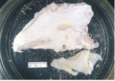
Bermuda Blob Bermuda Blob is the name given to two globsters that washed ashore on Bermuda in 1988 and 1997. Originally thought to be the remains of a cryptid, analysis proved the blobs to be the remains of whales. The first Bermuda Blob was found by Teddy Tucker, a fisherman and treasure hunter, in Mangrove Bay in May 1988. Tucker described the blob as "2½ to 3 feet thick . very white and fibrous . with five 'arms or legs,' rather like a disfigured star." Samples of the specimen were analysed in 1995 and it was suggested that these were from a poikilothermic sea creature, either a large teleost (bony fish) or an elasmobranch (shark or ray). Subsequent reanalysis of this specimen by the same team, however, using advanced genetic techniques not previously available, confirmed that it was actually the remains of a whale. Bermuda Blob 2 was found in January 1997. Analysis of samples in 2004 suggests that Bermuda Blob 2 was a large mass of adipose tissue from a whale.  

Trunko ( Lump of Flesh )

Image
Trunko Trunko is the nickname for a large unidentified lump of flesh or a decomposed sea creature, a so-called "globster", reportedly sighted in Margate, South Africa on 25 October 1924. The initial source for Trunko was an article entitled "Fish Like A Polar Bear" published on the 27 December 1924, edition of London's Daily Mail. The animal was reportedly first seen off the coast battling two killer whales, which fought the unusual creature for three hours. It used its tail to attack the whales and reportedly lifted itself out of the water by about 20 feet (6 m). One of the witnesses, South African farmer Hugh Ballance, described the animal as looking like a "giant polar bear" due to what was thought to be dense-white fur.[citation needed] The creature reputedly washed up on Margate Beach but despite being there for 10 days, no scientist investigated the carcass while it was beached, so no reliable description has been published, and until September 2...

Basking shark

Image
Basking shark The basking shark (Cetorhinus maximus) is the second-largest living shark and fish, after the whale shark, and one of three plankton-eating shark species, along with the whale shark and megamouth shark. Adults typically reach 7.9 m (26 ft) in length. It is usually greyish-brown, with mottled skin. The caudal fin has a strong lateral keel and a crescent shape. The basking shark is a cosmopolitan migratory species, found in all the world's temperate oceans. A slow-moving filter feeder, its common name derives from its habit of feeding at the surface, appearing to be basking in the warmer water there. It has anatomical adaptations for filter-feeding, such as a greatly enlarged mouth and highly developed gill rakers. Its snout is conical and the gill slits extend around the top and bottom of its head. The gill rakers, dark and bristle-like, are used to catch plankton as water filters through the mouth and over the gills. The teeth are numerous and very small, and often nu...

Zuiyo-maru carcass

Image
Zuiyo-maru Carcass  The Zuiyo-maru carcass was a corpse, most likely a basking shark, caught by the Japanese fishing trawler Zuiyō Maru off the coast of New Zealand in 1977. The carcass's peculiar appearance led to speculation that it might be the remains of a sea serpent or prehistoric plesiosaur. Although several scientists insisted it was "not a fish, whale, or any other mammal", analysis of amino acids in the corpse's muscle tissue later indicated it was most likely the carcass of a basking shark. Decomposing basking shark carcasses lose most of the lower head area and the dorsal and caudal fins first, making them resemble a plesiosaur. On April 25, 1977, the Japanese trawler Zuiyō Maru, sailing east of Christchurch, New Zealand, caught a strange, unknown creature in the trawl. The crew was convinced it was an unidentified animal, but despite the potential biological significance of the curious discovery, the captain, Akira Tanaka, decided to dump the carcass into...

Stronsay Beast

Image
Stronsay Beast The Stronsay Beast was a large globster that washed ashore on the island of Stronsay (at the time spelled Stronsa), in the Orkney Islands, Scotland, after a storm on 25 September 1808. The carcass measured 55 ft (16.8 m) in length, without part of its tail. The Natural History Society (Wernerian Society) of Edinburgh could not identify the carcass and decided it was a new species, probably a sea serpent. The Scottish naturalist Patrick Neill gave it the scientific name Halsydrus pontoppidani (Pontoppidan's sea-snake) in honor of Erik Pontoppidan, who described sea serpents in a work published half a century before. The anatomist Sir Everard Home in London later dismissed the measurement, declaring it must have been around 36 ft (11 m), and deemed it to be a decayed basking shark. In 1849, Scottish professor John Goodsir in Edinburgh came to the same conclusion. The Stronsay Beast was measured by a carpenter and two farmers. It was 4 ft (1.2 m) wide and had a circumfe...

St. Augustine Monster

Image
 St. Augustine Monster The St. Augustine Monster is the name given to a large carcass, originally postulated to be the remains of a gigantic octopus, that washed ashore on the United States coast near St. Augustine, Florida in 1896. It is sometimes referred to as the Florida Monster or the St. Augustine Giant Octopus and is one of the earliest recorded examples of a globster. The species that the carcass supposedly represented has been assigned the binomial names Octopus giganteus (Latin for "giant octopus") and Otoctopus giganteus (Greek prefix: oton = "ear"; "giant-eared octopus"), although these are not valid under the rules of the ICZN. A 1995 analysis concluded that the St. Augustine Monster was a large mass of the collagenous matrix of whale blubber, likely from a sperm whale.

New Zealand Globster

Image
New Zealand Globster A whale carcass, initially unidentified due to decomposition, was found washed ashore at Muriwai Beach, 42 kilometres from the centre of Auckland in New Zealand, in March 1965. At some point in time it was dubbed a "globster", after the Tasmanian Globster, a whale carcass found in Australia a few years earlier. The Auckland Star reported the find on its front page of 23 March 1965. At that time the carcass was 20 ft (6.1 m) long. It had a tough 1/4 inch thick hide, under which was a thin layer of what appeared to be fat, then solid meat. It was covered in what appeared to be "sand-matted grey hair four to six inches long". A Marine Department officer who had seen it more than a week earlier, said it had then been 30 ft (9.1 m) long by about 8 ft (2.4 m). The carcass was 15 miles from the southern end of the beach, and the article included two photographs of it. Shown photographs, John Morton, head of the zoology department at the University of A...

Tasmanian Globster

Image
Tasmanian Globster The Tasmanian Globster was a large unidentified carcass that washed ashore 2 miles (3.2 kilometres) north of Interview River in western Tasmania, in August 1960. It measured 20 ft (6.1 m) by 18 ft (5.5 m) and was estimated to weigh between 5 and 10 tons. The mass lacked eyes and in place of a mouth, had "soft, tusk-like protuberances". It had a spine, six soft, fleshy 'arms' and stiff, white bristles covering its body. The carcass was identified as a whale by L.E. Wall in the journal Tasmanian Naturalist in 1981, and a later electron microscopy analysis of the collagen fibers confirmed this. The term globster was coined in 1962 by Ivan T. Sanderson to describe this carcass and the name Sea Santa, coined by another journalist in the same year.  

The Wave (Arizona)

Image
The Wave (Arizona) The Wave is a sandstone rock formation located in Arizona, United States, near its northern border with Utah. The formation is situated on the slopes of the Coyote Buttes in the Paria Canyon-Vermilion Cliffs Wilderness of the Colorado Plateau. The area is administered by the Bureau of Land Management (BLM) at the Grand Staircase-Escalante National Monument visitor center in Kanab, Utah. The formation is well-known among hikers and photographers for its colorful, undulating forms and the difficult hike required to reach it. Due to the fragile nature of the formation and the large number of people wishing to visit it, a daily lottery system is used to dispense only ten next-day permits in person at the Kanab visitor center. Additionally, ten online permits for each date are available four months in advance of a planned trip. A map and information about the hike are supplied to those who have obtained permits.  

Brahmaputra River ( Tibet )

Image
 Brahmaputra River ( Tibet ) The Brahmaputra also known as the Yarlung Tsangpo in Tibet, the Siang/Dihang River in Arunachal Pradesh, and Luit, Dilao in Assam, is a trans-boundary river which flows through China, India, and Bangladesh.[a] It is the 9th largest river in the world by discharge, and the 15th longest. With its origin in the Manasarovar Lake region, near Mount Kailash, on the northern side of the Himalayas in Burang County of Tibet where it is known as the Yarlung Tsangpo River, it flows along southern Tibet to break through the Himalayas in great gorges (including the Yarlung Tsangpo Grand Canyon) and into Arunachal Pradesh. It flows southwest through the Assam Valley as the Brahmaputra and south through Bangladesh as the Jamuna (not to be confused with the Yamuna of India). In the vast Ganges Delta, it merges with the Ganges, popularly known as the Padma in Bangladesh, and becomes the Meghna and ultimately empties into the Bay of Bengal.

Strokkur

Image
Strokkur Strokkur (Icelandic [ˈstrɔhkʏr̥], "churn") is a fountain-type geyser located in a geothermal area beside the Hvítá River in Iceland in the southwest part of the country, east of Reykjavík. It typically erupts every 6–10 minutes. Its usual height is 15–20 metres (49–66 ft), although it can sometimes erupt up to 40 metres (130 ft) high. Strokkur belongs to the Haukadalur valley area, where various other geothermal feature such as mud pools, fumaroles and other geysers are located around it, such as the famous Geysir geyser, which lies only 160 feet to the north.  

Svartifoss

Image
Svartifoss Svartifoss (Icelandic for "black waterfall", [ˈsvar̥tɪˌfɔsː]) is a waterfall in Skaftafell in Vatnajökull National Park in Iceland, and is one of the most popular sights in the park. It is surrounded by dark lava columns, which gave rise to its name. The base of this waterfall is noteworthy for its sharp rocks. New hexagonal column sections break off faster than the falling water wears down the edges. These basalt columns have provided inspiration for Icelandic architects, most visibly in the Hallgrímskirkja church in Reykjavík, and also the National Theatre.  

Honghe Hani Rice Terraces

Image
Honghe Hani Rice Terraces The Honghe Hani Rice Terraces are the system of Hani rice-growing terraces located in Honghe Prefecture, Yuanyang County, Yunnan, China. The terraces' history spans around 1,200 years. The total area stretches across 1,000,000 acres and four counties: Yuanyang, Honghe, Jinpin and Lüchun, although the core area of the terraces is located in Yuanyang County. In 2013, 16,603 hectares of the Honghe Hani Rice Terraces were listed as a World Heritage Site, because of their outstanding resilient construction, unique social-ecological system, and importance to the Hani people.  

Plateau of Valensole

Image
Plateau of Valensole The Valensole plateau is a natural region of France located in the Alpes-de-Haute-Provence , south-west of Digne-les-Bains , between the valleys of the Durance to the west, the Asse to the north, Gorges du Verdon and Lake Sainte-Croix to the south. Its average altitude is 500  m and it extends over 800  km 2 . It is crossed by the Asse valley , which separates it into two asymmetrical parts.  

Aurora

Image
Aurora An aurora  also known as the polar lights or aurora polaris, is a natural light display in Earth's sky, predominantly seen in high-latitude regions (around the Arctic and Antarctic). Auroras display dynamic patterns of brilliant lights that appear as curtains, rays, spirals, or dynamic flickers covering the entire sky. Auroras are the result of disturbances in the magnetosphere caused by solar wind. These disturbances alter the trajectories of charged particles in the magnetospheric plasma. These particles, mainly electrons and protons, precipitate into the upper atmosphere (thermosphere/exosphere). The resulting ionization and excitation of atmospheric constituents emit light of varying colour and complexity. The form of the aurora, occurring within bands around both polar regions, is also dependent on the amount of acceleration imparted to the precipitating particles. Most of the planets in the Solar System, some natural satellites, brown dwarfs, and even comets also host ...

Plitvice Lakes National Park

Image
Plitvice Lakes National Park Plitvice Lakes National Park (Croatian: Nacionalni park Plitvička jezera, colloquially Plitvice, pronounced is one of the oldest and largest national parks in Croatia. In 1979, Plitvice Lakes National Park was inscribed on the UNESCO World Heritage list, due to its outstanding and picturesque series of tufa lakes, caves, connected by waterfalls.The national park was founded in 1949 and is in the mountainous karst area of central Croatia, at the border to Bosnia and Herzegovina. The important north–south road that passes through the national park area connects the Croatian inland with the Adriatic coastal region. The protected area extends over 296.85 square kilometres (73,350 acres). About 90% of this area is part of Lika-Senj County, while the remaining 10% is part of Karlovac County. Each year, more than 1 million visitors are recorded. Entrance is subject to variable charges, up to 250 kuna or around €34 per adult per day in summer 2018.

Taal Lake

Image
Taal Lake Taal Lake formerly known as Bombón Lake, is a freshwater caldera lake in the province of Batangas, on the island of Luzon in the Philippines. The lake fills Taal Volcano, a large volcanic caldera formed by very large eruptions between 500,000 and 100,000 years ago. It is the country's third-largest lake, after Laguna de Bay and Lake Lanao. Volcano Island, the location of Taal Volcano's historical eruptions and responsible for the lake's sulfuric content, lies near the center of the lake. Up until the 2020 eruption of Taal Volcano there was a crater lake on Volcano Island. It was known as Yellow Lake and Main Crater Lake and contained its own small island, Vulcan Point. Vulcan Point was thought to be one of few third-order islands in the world.  

Spotted Lake

Image
Spotted Lake Spotted Lake is a saline endorheic alkali lake located northwest of Osoyoos in the eastern Similkameen Valley of British Columbia, Canada, accessed via Highway 3. Spotted Lake is richly concentrated with various minerals. It contains dense deposits of magnesium sulfate, calcium and sodium sulphates. It also contains high concentrations of eight other minerals and lower amounts of silver and titanium. Most of the water in the lake evaporates over the summer, revealing colorful mineral deposits. Large 'spots' on the lake appear and are colored according to the mineral composition and seasonal amount of precipitation. Magnesium sulfate, which crystallizes in the summer, is a major contributor to spot color. In the summer, remaining minerals in the lake harden to form natural “walkways” around and between the spots.  

Abraham Lake

Image
Abraham Lake Abraham Lake, also known as Lake Abraham, is an artificial lake and Alberta's largest reservoir. It is located in the "Kootenay Plains area of the Canadian Rockies' front range", on the North Saskatchewan River in western Alberta, Canada.   Trapped methane causes frozen bubbles to form under the ice on the lake's surface. This phenomenon results when decaying plants on the lake bed release methane gas, which creates bubbles that become trapped within the ice, in suspended animation, just below the surface as the lake begins to freeze. The visual effects formed by the resulting stacks of bubbles, frozen while rising toward the surface, combined with the clear blue water, have made Abraham Lake a popular destination for photographers and nature observers. The ice coverage of the lakes varies throughout the winter. It usually freezes by the end of December but did not freeze until January in 2020.

Crater Lake

Image
Crater Lake Crater Lake (Klamath: Giiwas) bis a crater lake in south-central Oregon in the western United States. It is the main feature of Crater Lake National Park and is famous for its deep blue color and water clarity. The lake partly fills a 2,148-foot-deep (655 m) caldera that was formed around 7,700 (± 150) years ago by the collapse of the volcano Mount Mazama. There are no rivers flowing into or out of the lake; the evaporation is compensated for by rain and snowfall at a rate such that the total amount of water is replaced every 250 years. With a depth of 1,949 feet (594 m), the lake is the deepest in the United States. In the world, it ranks ninth for maximum depth, and third for mean (average) depth. Crater Lake features two small islands. Wizard Island, located near the western shore of the lake, is a cinder cone approximately 316 acres (128 ha) in size. Phantom Ship, a natural rock pillar, is located near the southern shore. Since 2002, one of Oregon's regular-issue li...

Lakes In Badain Jaran Desert

Image
Lakes In Badain Jaran Desert A desert oasis is usually a sight to behold, providing a welcome respite from the apparently unending stretch of brown sand. The Badain Jaran Desert, which stretches from Mongolia to China, contains a total of 140 permanent lakes dotting its dry landscape. The lakes, which are located between sand dunes, are said to have originated from subsurface springs fed by precipitation from the nearby mountain's snowy peaks, despite the fact that these ranges are hundreds of kilometers distant.  

Balancing Rock (Balanced Rock)

Image
Balancing Rock (Balanced Rock) A balancing rock, also called a balanced rock or precarious boulder, is a naturally occurring geological formation featuring a large rock or boulder, sometimes of substantial size, resting on other rocks, bedrock, or on glacial till. Some formations known by this name only appear to be balancing, but are in fact firmly connected to a base rock by a pedestal or stem. No single scientific definition of the term exists, and it has been applied to a variety of rock features that fall into one of four general categories: 1.Glacial erratic 2.Perched block 3.Erosional remnant 4.Pedestal rock

Giant's Causeway

Image
Giant's Causeway  The Giant's Causeway is an area of about 40,000 interlocking basalt columns, the result of an ancient volcanic fissure eruption. It is located in County Antrim on the north coast of Northern Ireland, about three miles (5 km) northeast of the town of Bushmills. It was declared a World Heritage Site by UNESCO in 1986 and a national nature reserve in 1987 by the Department of the Environment for Northern Ireland. In a 2005 poll of Radio Times readers, the Giant's Causeway was named the fourth greatest natural wonder in the United Kingdom. The tops of the columns form stepping stones that lead from the cliff foot and disappear under the sea. Most of the columns are hexagonal, although there are also some with four, five, seven or eight sides. The tallest are about 12 metres (39 ft) high, and the solidified lava in the cliffs is 28 metres (92 ft) thick in places. Much of the Giant's Causeway and Causeway Coast World Heritage Site is owned and managed by the...

The Immortal Bridge in Mount Tai

Image
  The Immortal Bridge in Mount Tai Mount Tai is a mountain of historical and cultural significance located north of the city of Tai'an. It is the highest point in Shandong province, China. The tallest peak is the Jade Emperor Peak which is commonly reported as being 1,545 meters (5,069 ft) tall. Mount Tai is a tilted fault-block mountain with height increasing from the north to the south. It is the oldest example of a paleo-metamorphic formation from the Cambrian Period in eastern China. Known as the Taishan Complex, this formation contains magnetized, metamorphic, and sedimentary rock as well as intrusions of other origins during the Archean Era. The uplift of the region started in the Proterozoic Era; by the end of the Proterozoic, it had become part of the continent. Besides the Jade Emperor Peak, other distinctive rock formations are the Heaven Candle Peak, the Fan Cliff, and the Rear Rock Basin. Mount Tai lies in the zone of oriental deciduous forest; about 80% of its area is ...

Árbol de Piedra (Stone Tree)

Image
Árbol de Piedra Árbol de Piedra ("stone tree") is an isolated rock formation in the Eduardo Avaroa Andean Fauna National Reserve of Sur Lípez Province, Bolivia. Much photographed, it projects out of the altiplano sand dunes of Siloli in the Potosí Department, about 18 kilometres (11 mi) north of Laguna Colorada. Known as the "Stone Tree," it is shaped like a stunted tree about 7 m high. Its shape, particularly the thin stem, are due to strong winds carrying sand and eroding the soft sandstone.

Uluru (Ayers Rock)

Image
Uluru (Ayers Rock)  Ayers Rock. Uluru also known as Ayers Rock and officially gazetted as Uluru / Ayers Rock, is a large sandstone formation in the southern part of the Northern Territory in Australia. It lies 335 km (208 mi) southwest of the nearest large town: Alice Springs. Uluru is sacred to the Pitjantjatjara, the Aboriginal people of the area, known as the Aṉangu. The area around the formation is home to an abundance of springs, waterholes, rock caves, and ancient paintings. Uluru is listed as a UNESCO World Heritage Site. Uluru and Kata Tjuta, also known as the Olgas, are the two major features of the Uluṟu-Kata Tjuṯa National Park. Uluru is one of Australia's most recognisable natural landmarks and has been a popular destination for tourists since the late 1930s. It is also one of the most important indigenous sites in Australia.

Old Harry Rocks

Image
Old Harry Rocks  Old Harry Rocks are three chalk formations, including a stack and a stump, located at Handfast Point, on the Isle of Purbeck in Dorset, southern England. They mark the most eastern point of the Jurassic Coast, a UNESCO World Heritage Site. The chalk of Old Harry Rocks used to be part of a long stretch of chalk between Purbeck and the Isle of Wight, but remained as a headland after large parts of this seam were eroded away. As the headland suffered hydraulic action (a process in which air and water are forced into small cracks by the force of the sea, resulting in enlarging cracks), first caves, then arches formed. The tops of the arches collapsed after being weakened by rainfall and wind, leaving disconnected stacks. One of these stacks is known as Old Harry. Old Harry's Wife was another stack which was eroded through corrosion and abrasion, until the bottom was so weak the top fell away, leaving a stump. Hydraulic action is the main cause of erosion (sheer force o...

Petra tou Romiou (Aphrodite's Rock)

Image
 Petra tou Romiou (Aphrodite's Rock) Petra tou Romiou ("Rock of the "Roman") (that is East Roman or Byzantine as Byzantines referred to themselves as either Greeks or Romans until the 1820s), also known as Aphrodite's Rock, is a sea stack in Paphos, Cyprus. It is located off the shore along the main road from Paphos to Limassol. The combination of the beauty of the area and its status in mythology as the birthplace of Aphrodite makes it a popular tourist location. The sea in this region is generally rough, persuading tourists not to swim there. It is not permitted to climb the rock. A restaurant, a tourist pavilion and the Aphrodite Hills resort are nearby.

The Moynaq Ship Graveyard

Image
The Moynaq Ship Graveyard Moʻynoq, also spelled as Muynak and Moynaq is a city in northern Karakalpakstan, an autonomous republic in Uzbekistan. Formerly a sea port on the Aral Sea, it is now 150 km from the water in the Aralkum Desert and thus is a disaster tourism destination. It is also the location for the biggest electronic music festival in Central Asia. Once a bustling fishing community and Uzbekistan's only port city with tens of thousands of residents, Moʻynoq is now dozens of kilometers from the rapidly receding shoreline of the Aral Sea. Fishing had always been part of the economy of the region, and Moʻynoq became a center of industrial fishing and canning. However, a 1960s Soviet government diversion of the Amu Darya and Syr Darya rivers sapped the Aral Sea of its inflows, causing much of the lake to dry up and thus leaving the area susceptible to economic collapse. The regional Soviet-led agricultural monoculture dominated by cotton production diverted water from the a...

Fingal's Cave

Image
Fingal's Cave Fingal's Cave is a sea cave on the uninhabited island of Staffa, in the Inner Hebrides of Scotland, known for its natural acoustics. The National Trust for Scotland owns the cave as part of a national nature reserve. It became known as Fingal's Cave after the eponymous hero of an epic poem by 18th-century Scots poet-historian James Macpherson. Fingal's Cave is formed entirely from hexagonally jointed basalt columns within a Paleocene lava flow, similar in structure to the Giant's Causeway in Northern Ireland and those of nearby Ulva. In all these cases, cooling on the upper and lower surfaces of the solidified lava resulted in contraction and fracturing, starting in a blocky tetragonal pattern and transitioning to a regular hexagonal fracture pattern with fractures perpendicular to the cooling surfaces. As cooling continued these cracks gradually extended toward the centre of the flow, forming the long hexagonal columns we see in the wave-eroded cross-...

Grand Prismatic Spring (Boiling Lake)

Image
Grand Prismatic Spring The Grand Prismatic Spring in Yellowstone National Park is the largest hot spring in the United States, and the third largest in the world, after Frying Pan Lake in New Zealand and Boiling Lake in Dominica. It is located in the Midway Geyser Basin. Grand Prismatic Spring was noted by geologists working in the Hayden Geological Survey of 1871, and named by them for its striking coloration. Its colors match most of those seen in the rainbow dispersion of white light by an optical prism: red, orange, yellow, green, and blue.  

Blue Hole

Image
Blue Hole  A blue hole is a large marine cavern or sinkhole, which is open to the surface and has developed in a bank or island composed of a carbonate bedrock (limestone or coral reef). Their existence was discovered in the late 20th century by fishermen and recreational divers. Blue holes typically contain tidally influenced water of fresh, marine, or mixed chemistry. They extend below sea level for most of their depth and may provide access to submerged cave passages. Well-known examples are the Dragon Hole (in the South China Sea) and, in the Caribbean, the Great Blue Hole and Dean's Blue Hole. Blue holes are distinguished from cenotes in that the latter are inland voids usually containing fresh groundwater rather than seawater.

General Sherman (Tree)

Image
 General Sherman (tree) General Sherman is a giant sequoia (Sequoiadendron giganteum) tree located in the Giant Forest of Sequoia National Park in Tulare County, in the U.S. state of California. By volume, it is the largest known living single-stem tree on Earth. It is estimated to be around 2,200 to 2,700 years old. While the General Sherman is the largest currently living tree, it is not the largest historically recorded tree. The Lindsey Creek tree, with more than 90,000 cubic feet (2,500 cubic meters) almost twice the volume of General Sherman, was reported felled by a storm in 1905. Another larger coast redwood, the Crannell Creek Giant, a coast redwood (Sequoia sempervirens) cut down in the mid-1940s near Trinidad, California, is estimated to have been 15–25% larger than the General Sherman tree by volume.

Musa ingens (Biggest Banana Tree Ever)

Image
Musa Ingens The plant species Musa ingens is the physically largest member of the family Musaceae and the only member of the section Ingentimusa. Growing in the tropical montane forests of New Guinea - Arfak Mountains Regency - Indonesia, its leaves can reach a length of 5 meters (16 feet) and a width of 1 m (39 inches). The "trunk" (actually the tightly rolled petioles (or stalks) of its leaves; the longest petioles of any known plant) is typically up to 15 meters (49 feet) in height, and with the leaves having a total height of 20 meters (66 feet). However, since its discovery in 1954 taller individuals up to thirty meters (98 feet) have been reported, but these measurements have yet to be confirmed by a specific scientific study. Photos exist of M. ingens "trunks" up to 94 centimetres (37 in) in diameter at breast height. Its fruit, in a cluster weighing up to 60 kg (132 lbs). This cluster is borne on a peduncle up to 10 cm (4 in) thick and up to 15 m (49 ft) in ...

The Dark Hedges

Image
 The Dark Hedges The Dark Hedges is an avenue of beech trees along Bregagh Road between Armoy and Stranocum in County Antrim, Northern Ireland. The trees form an atmospheric tunnel that has been used as a location in HBO's popular television series Game of Thrones, which has resulted in the avenue becoming a popular tourist attraction.

Sinkhole

Image
Sinkhole A sinkhole is a depression or hole in the ground caused by some form of collapse of the surface layer. The term is sometimes used to refer to doline, enclosed depressions that are locally also known as vrtače and shakeholes, and to openings where surface water enters into underground passages known as ponor, swallow hole or swallet. A cenote is a type of sinkhole that exposes groundwater underneath. A sink or stream sink are more general terms for sites that drain surface water, possibly by infiltration into sediment or crumbled rock.  Most sinkholes are caused by karst processes – the chemical dissolution of carbonate rocks, collapse or suffosion processes. Sinkholes are usually circular and vary in size from tens to hundreds of meters (or yards) both in diameter and depth, and vary in form from soil-lined bowls to bedrock-edged chasms. Sinkholes may form gradually or suddenly, and are found worldwide.

Moving Rocks

Image
Moving Rocks Sailing stones (also called sliding rocks, walking rocks, rolling stones, and moving rocks) are part of the geological phenomenon in which rocks move and inscribe long tracks along a smooth valley floor without animal intervention. The movement of the rocks occurs when large sheets of ice a few millimeters thick and floating in an ephemeral winter pond break up on sunny days. Frozen during cold winter nights, these thin, floating ice panels are driven by wind and shove rocks at speeds up to 5 meters per minute. Trails of sliding rocks have been observed and studied in various locations, including Little Bonnie Claire Playa, in Nevada, and most famously at Racetrack Playa, Death Valley National Park, California, where the number and length of tracks are notable.

Dead Sea

Image
Dead Sea The Dead Sea is a salt lake bordered by Jordan to the east and Israel and the West Bank to the west. It lies in the Jordan Rift Valley, and its main tributary is the Jordan River.

Bermuda Triangle

Image
Bermuda Triangle  The Bermuda Triangle, also known as the Devil's Triangle, is a loosely defined region in the western part of the North Atlantic Ocean where a number of aircraft and ships are said to have disappeared under mysterious circumstances. The idea of the area as uniquely prone to disappearances arose in the mid-20th century, but most reputable sources dismiss the idea that there is any mystery.

Blood Falls

Image
Blood Falls Blood Falls is an outflow of an iron oxide-tainted plume of saltwater, flowing from the tongue of Taylor Glacier onto the ice-covered surface of West Lake Bonney in the Taylor Valley of the McMurdo Dry Valleys in Victoria Land, East Antarctica.  

Lake Hillier

Image
Lake Hillier  Lake Hillier is a saline lake on the edge of Middle Island, the largest of the islands and islets that make up the Recherche Archipelago in the Goldfields-Esperance region, off the south coast of Western Australia. It is particularly notable for its pink colour. A long and thin shore divides the Southern Ocean (by some definitions, the Indian Ocean) from the lake.

Lake Natron

Image
Lake Natron  Lake Natron is a salt or alkaline lake located in north Ngorongoro District of Arusha Region in Tanzania. It is in the Gregory Rift, which is the eastern branch of the East African Rift. The lake is within the Lake Natron Basin, a Ramsar Site wetland of international significance.

Snake Island

Image
Snake Island Ilha da Queimada Grande, also known as Snake Island, is an island off the coast of Brazil in the Atlantic Ocean. It is administered as part of the municipality of Itanhaém in the State of São Paulo. The island is small in size, only 43 hectares (106 acres), and has a temperate climate. The island's terrain varies considerably, ranging from bare rock to rainforest.

DANAKIL DESERT

Image
Danakil Desert  The Danakil Desert is a desert in northeast Ethiopia, southern Eritrea, and northwestern Djibouti. Situated in the Afar Triangle, it stretches across 136,956 square kilometres (52,879 sq mi)[citation needed] of arid terrain. It is inhabited by a few Afar, who engage in salt mining. The area is known for its volcanoes and extreme heat, with daytime temperatures surpassing 50 °C (122 °F). Less than 25 mm (1 in) of rainfall occurs each year. The Danakil Desert is one of the lowest and hottest places on Earth.

The Island of the Dolls

Image
The Island of the Dolls The Island of the Dolls (La Isla de las Muñecas), located in the channels of Xochimilco, south of the center of Mexico City, very close to the Estadio Azteca football stadium, is a chinampa of the Laguna de Teshuilo and one of the main attractions of the channels. Dolls of various styles and colors are found throughout the island, originally placed by the former owner of the island, Julián Santana Barrera. He believed that dolls helped to chase away the spirit of a girl who drowned years ago. He died in 2001 of a heart attack. Sources say he was close to the same spot where the girl drowned.  

Easter Island

Image
Easter Island Easter Island (Rapa Nui: Rapa Nui; Spanish: Isla de Pascua) is an island and special territory of Chile in the southeastern Pacific Ocean, at the southeasternmost point of the Polynesian Triangle in Oceania. The island is most famous for its nearly 1,000 extant monumental statues, called moai, which were created by the early Rapa Nui people. In 1995, UNESCO named Easter Island a World Heritage Site, with much of the island protected within Rapa Nui National Park. Experts disagree on when the island's Polynesian inhabitants first reached the island. While many in the research community cited evidence that they arrived around the year 800, convincing data presented in a 2007 study suggests the their arrival to have been closer to 1200. The inhabitants created a thriving and industrious culture, as evidenced by the island's numerous enormous stone moai and other artifacts. However, land clearing for cultivation and the introduction of the Polynesian rat led to gradu...